New Point Comfort Lighthouse

New Point Comfort Chesapeake Bay Virginia
Chesapeake Bay Virginia History
Middle Peninsula Mathews Virginia
Chesapeake Bay Virginia Sailing
Chesapeake Bay Virginia Fishing
Chesapeake Bay Virginia Kayaking Canoeing
Chesapeake Bay VirginiaRowing
Chesapeake Bay Nature
Virginia Biking
Chesapeake Bay Virginia Weather
Chesapeake Bay Navigation
Chesapeake Bay Virginia Links
Contact New Point Comfort
Chesapeake Bay Paintings and Artwork

New Point Comfort Logo
Mathews County Virginia Davis Creek Watermans Seafood PierMathews County Virginia New Point Comfort Mathews County Virginia Title

Mathews County Virginia Title

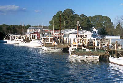
Few locations in the world offer better scenic waterfront settings than Mathews, a County of quaint hamlets and maritime villages that extends southward from the Piankatank River to the tip of the New Point Comfort peninsula. It is an area of unparalleled natural beauty, with over 200 miles of pristine shoreline along the Chesapeake and Mobjack Bays, and the East, North, and Piankatank Rivers.

New Point Comfort Location Map New Point Comfort Location Map
How to Find New Point Comfort Map How to Find New Point Comfort
Mathews County Virginia Road Map             County Virginia Road Map</a></font> Mathews County Virginia Road Map
Courthouse Square Mathews County Courthouse Square

Home | History | Local | Sailing | Fishing | Paddling | Rowing | Nature | Biking | Weather | Navigation | Links | Contact Us | Shop
Do you need to upgrade your Browser or Flash Plugin?

Copyright © 2006 InterMarket Advertising. All Rights Reserved.