|
||||||
We are certain, however, that Captain John Smith passed by New Point Comfort in the summer of 1608 on his return trip to Jamestown after searching for gold in the northern Chesapeake Bay. Numerous thunderstorms and strong westerly winds forced Smith and his crew of fourteen to travel back along the western shores of the bay. His tiny ship grounded near the mouth of the Rappanhannock River. It was here that he was stung by the tail of a stingray after spearing it with his sword. The area is still called "Stingray Point" today. During this trip Smith made detailed charts of the land, bay, and rivers from which he produced an amazingly accurate map of the Chesapeake Bay. For many years afterwards this map remained the only navigational document available to colonial mariners.
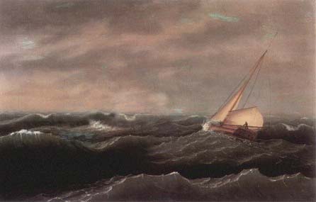
For protection from the threatening northeasterly winds, salty sea captains liked the protected waters of the Mobjack Bay just southwest of New Point Comfort. Square riggers and schooners out of Annapolis or Baltimore running before a gale would round New Point and seek the comfort of its safe anchorage. Others heading North would drop the hook there else be blown onto the beaches or marshes of York or Hampton Roads. Amidst the fury of the storm, some ships missed their mark and were dashed to pieces upon New Point's southeastern shoals and submerged beaches. It's not known how many ships met their fate there before the lighthouse was built. The later part of the eighteenth century was a particularly active time for storms of great winds and rains.
In 1788, the George Washington Hurricane, "passed directly over the lower Chesapeake. Winds originated from the northeast then shifted abruptly from the South, tearing down chimneys and moving houses from their foundations. Many plantations in Mathews and Gloucester Counties saw their houses leveled, others were flooded with water six feet deep. Gloucester County was inundated, $400,000 in damage was incurred." After the Revolutionary war members of the First Congress realized the need to make the coastal waters less hazardous. On August 7, 1789 one of the the first acts provided for aids to navigation. Funds were appropriated for the construction of lighthouses, beacons, and buoys. The act also provided for the building of a lighthouse at Cape Henry near the southeast entrance to the Chesapeake Bay.
Cape Henry was the first lighthouse on the Chesapeake, and became operational in 1792. George Washington, who took great interest in lighthouses during this time, appointed William Lewis to become the first keeper of the light. This was an active time for the building of lighthouses and the federal government made plans to construct a second lighthouse on the Chesapeake Bay
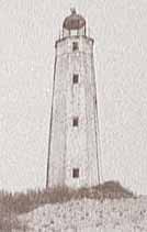
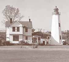
Old Point Comfort was completed in 1802 at what is now Fort Monroe in Hampton, Virginia. The lighthouse stands 54 feet and was the first to be built by Elzy Burroughs, who would later build the New Point Comfort Lighthouse about 21 miles to the North in Mathews County, Virginia.
References Cited: National Oceanic and Atmospheric Administration, Hurricane History - http://www.hpc.ncep.noaa.gov/research/roth/vahur.htm Old Cape Henry Lighthouse Virginia Beach, VA (photo USCG) Old Point Comfort Lighthouse Fort Monroe, Hampton, VA (photo USCG)
|
||||||
Home | History | Local | Sailing | Fishing | Paddling | Rowing | Nature | Biking | Weather | Navigation | Links | Contact
Us | Shop Copyright © 2006 InterMarket Advertising. All Rights Reserved. |
.gif)

 History
tells us very little about the early American Indians who once
lived in what is Mathews County today. They most likely traveled
to New Point Comfort often in their canoes in search of the rich
bounty of fish, crabs, oysters and clams there.
History
tells us very little about the early American Indians who once
lived in what is Mathews County today. They most likely traveled
to New Point Comfort often in their canoes in search of the rich
bounty of fish, crabs, oysters and clams there.
 Throughout
the 1600 and 1700's early Americans experienced countless problems
navigating the waters of the new world. The Chesapeake Bay with its
shallow depths and numerous shoals was no exception. Many ships, cargo,
and crews perished during storms and hurricanes.
Throughout
the 1600 and 1700's early Americans experienced countless problems
navigating the waters of the new world. The Chesapeake Bay with its
shallow depths and numerous shoals was no exception. Many ships, cargo,
and crews perished during storms and hurricanes. 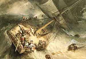 In
1785, "the most tremendous gale of wind known in this country
passed over the lower Chesapeake Bay, lower stories of dwellings were
flooded, and some warehouses were carried away. Vessels floated inland
into cornfields and wooded areas."
In
1785, "the most tremendous gale of wind known in this country
passed over the lower Chesapeake Bay, lower stories of dwellings were
flooded, and some warehouses were carried away. Vessels floated inland
into cornfields and wooded areas."